![]()
![]()
![]()
![]()
![]()
![]()


MY MAPS
Regions:
![]()
Browse the website:
Latest Acquisitions
A Brief History of Cartography
The Cartographers
Events on ancient maps
Accimo editions
Brochure MB
Contacts
Glossary
Sitemap
|
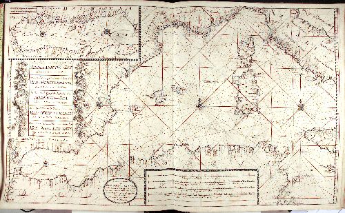
392-Mar mediterraneo Van Keulen Description: This map comes from the Ioannes van Keulen atlas Zee-Atlas ofte Water Waereld, printed in 1706 in Amsterdam. Measuring 59 x 94 cm, it shows the Western basin of the Mediterranean Sea, from the Strait of Gibraltar to Malta. The Adriatic Sea (Golfo di Venezia), from Venice to Otranto appears on a square at the top. Another square with festoons on the left, includes the title written in Dutch, English, French, Spanish and Italian. At the bottom are four graphic scales in Dutch and Italian miles, in French, English and Spanish leagues. Beside these there is a circle with the author's indication Amsterdam by Ioannes van Keulen. This graduated map has a central wind rose, situated between Sardinia and the Balearic Islands, which is connected with numerous other wind roses, but only three of them are visible. Other two wind roses are over the Adriatic Sea. It is an exquisite nautical map. Autor: Van Keulen Place: Amsterdam Year: 1706 Quality document:
See online :
Go to verification |