![]()
![]()
![]()
![]()
![]()
![]()


MY MAPS
Regions:
![]()
Browse the website:
Latest Acquisitions
A Brief History of Cartography
The Cartographers
Events on ancient maps
Accimo editions
Brochure MB
Contacts
Glossary
Sitemap
|
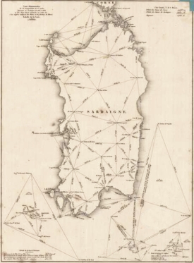
316-Carte demonstrative de la triangulation de 1er ordre executee en sardaigne de 1835 a Description: The map is on a scale of 1:1 000 000, measures 35,2 x 26 cm and proposes the basis of the first topographic measurement of the Sardinia Island. Autor: Alberto Lamarmora Place: Year: 0 Quality document:
See online :
Go to verification |