![]()
![]()
![]()
![]()
![]()
![]()


MY MAPS
Regions:
![]()
Browse the website:
Latest Acquisitions
A Brief History of Cartography
The Cartographers
Events on ancient maps
Accimo editions
Brochure MB
Contacts
Glossary
Sitemap
|
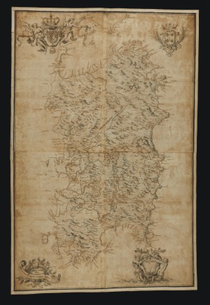
304-Nova et acurata Totius Sardiniae Tabula Description: The rather big map, printed in 1720, measures 113,5 x 74 cm, has no gradueted margins but four decorated pictures. It's the first cartographic document realized by the House of Savoy after acquiring the Empire of Sardinia. Autor: Domenico Colombino Place: Year: 1720 Quality document:
See online :
Go to verification |