![]()
![]()
![]()
![]()
![]()
![]()


MY MAPS
Regions:
![]()
Browse the website:
Latest Acquisitions
A Brief History of Cartography
The Cartographers
Events on ancient maps
Accimo editions
Brochure MB
Contacts
Glossary
Sitemap
|
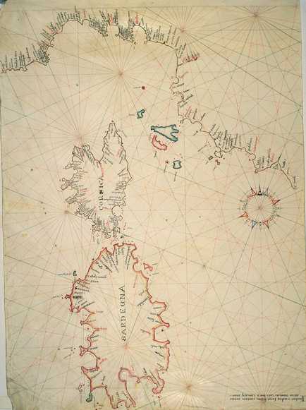
225-Thyrrenian Sea Description: The map measures 46,5 x 65,6 cm and represents a large part of the Thyrrenian Sea. Down on the right are reported the author's name, the place and the date of the map's redaction: Iacobus Maiolus fecit cartam Genue anno domini 1567 diem ianuarii XXX. Further on the right we can see a very beautiful wind rose from which depart 32 directions crossing in 9 different points. It's a typical nautical chart, very beatiful even if very schematic. It shows the coast profil and gives a lot of interesting informations for the navigation. There is no description of the inside area. Autor: Jacobus Maiolus Place: Genova Year: 1567 Quality document: A+
See online :
Go to verification |

See the printed version: Click here